Case study  /  Shirley

Woods Farm, what the land
could carry.

A working Christmas tree farm on the southern edge of Shirley, wholly in the West Midlands Green Belt, masterplanned into nine development parcels held inside a green framework, and promoted through Solihull's Local Plan Review as proposed allocation BL3.

Aerial view of Woods Farm on the southern edge of Shirley in Solihull: long parallel rows of Christmas trees across the foreground, mown grass avenues between them, a farm building among mature oaks, and the wooded suburban edge of Shirley along the horizon

Woods Farm: a working Christmas tree farm on the southern edge of Shirley, bounded by the Stratford-upon-Avon Canal to the south and a mainline railway to the west. Aerial, June 2022.

The facts

Strategic masterplanning architects, Solihull.

Land at Woods Farm, Bills Lane, on the southern edge of Shirley: a working farm in the Green Belt, promoted for release through the Local Plan Review on the strength of the masterplan and the evidence behind it.

The project

Four hundred and twenty nine, tested.

429homes tested across nine parcels
Location
Bills Lane, Shirley, Solihull
Client
A private landowning family
Our scope
Lead architect and masterplanner: the pre-application document, the design code, and the promotion masterplan
Status
Promoted as proposed allocation BL3. No consent, nothing built

A pre-application and site-promotion project, RIBA Stages 1 and 2, from appointment in 2022 to late 2023. Our role was to build the design case, not to secure a planning consent. The joint highway modelling basis later agreed with the council, across all promoters, was up to 750 dwellings.

The brief

What is this land actually worth?

The whole holding sits in the West Midlands Green Belt, where new building is restricted on principle, so the land is worth broadly what can credibly be built on it and not much more.

Solihull faced a large, contested housing requirement that could only be met by releasing Green Belt through the Local Plan Review, and Shirley was identified as a sustainable location capable of taking it. The question was not what to draw, but how much the land could credibly support.

Designation
West Midlands Green Belt throughout
Existing use
A working Christmas tree farm
Edges
Stratford-upon-Avon Canal south, mainline railway west
Basis
Garden city principles, with green infrastructure as the primary driver
Question
How much can this land carry, and how is that argued
The parcels

Nine parcels, one density.

Parcels
9, bounded by retained mature hedgerows
Density
35 dwellings per hectare, consistent across every parcel
Largest
2.87 ha, carrying 100 homes
Smallest
0.16 ha, carrying 6
Developable
12.25 ha of parcels, about 30.3 acres
Tested
429 homes, with the case made for up to 460

Parcel areas and densities from the accommodation schedule in the pre-application document, July 2022. The figure given is the developable parcel total, not the area of the holding. Quantum is indicative at promotion stage.

The scheme

A green framework first, the homes within it.

The logic of the masterplan is a landscape one. The green framework is set first, the canal, a continuous biodiversity corridor and the retained hedgerows, and the development parcels are fitted inside it.

The masterplan

Nine parcels in a green frame.

A biodiversity corridor crosses from the open land in the east to the canal in the south, the hedgerows hold the parcel boundaries, and the listed farmhouse sits in a green buffer. Access is off Bills Lane at two new three-arm roundabouts, designed by the highway engineer.

The masterplan, drawing 100E. Concept stage and indicative.

The quantum

Where the four hundred and twenty nine sit.

The nine parcels are the arithmetic of the promotion: each bounded by hedgerows that already exist, each at 35 dwellings per hectare, together carrying 429 homes across 12.25 hectares of developable land. One density across every parcel makes the total testable.

The parcel boundaries alone, taken from the masterplan's own drawing layers.

The place

A waterfront the site does not yet have.

The canal is the site's southern edge and the long accepted boundary of Dickens Heath. Rather than turn its back on it, the masterplan puts a marina and a landscaped waterfront there, so the green corridor arrives somewhere rather than simply stopping at a hedge.

Indicative concept: a study model of the canal-side marina, not a detailed design.

The gap before the drawing

A strategic site is argued, not drawn.

On Green Belt land, the case comes first.

Nobody hands a landowner a developable area. It has to be argued through the plan process, evidenced, and held against the edges around it. Get that wrong and the acreage on the title deed means very little.

Test a strategic site
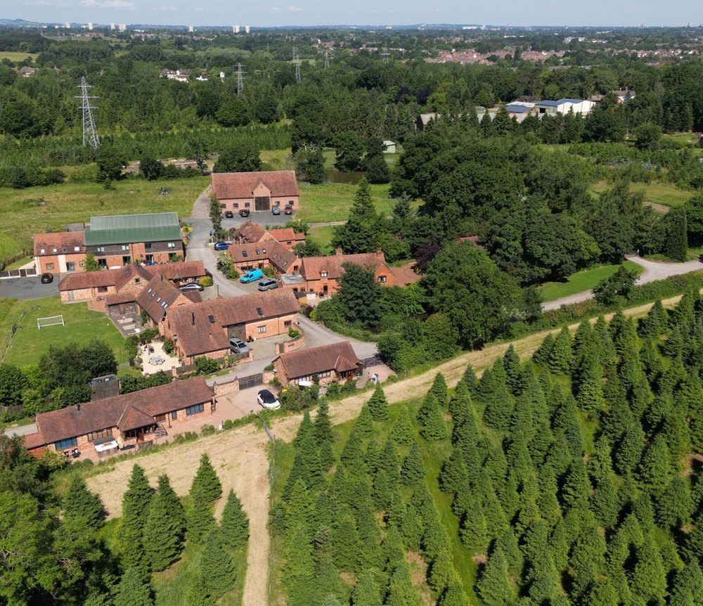
Aerial photograph of the Whitlocks Farmhouse cluster at Woods Farm: a group of brick farm buildings with clay tile roofs among mature trees, rows of Christmas trees running away to one side, and the Birmingham skyline on the far horizon

The listed farmhouse cluster at the centre of the site, with the working tree farm around it and the Birmingham skyline on the horizon. The city on the skyline is the point: this is an edge, not open countryside.

The full story

A private landowning family owned Woods Farm, a working Christmas tree farm on the southern edge of Shirley in Solihull, bounded by the Stratford-upon-Avon Canal to the south and a mainline railway to the west. The whole holding sits in the West Midlands Green Belt, where new building is restricted on principle, so the land is worth broadly what can credibly be built on it, and not much more.

Solihull, though, faced a large and contested housing requirement. The Greater Birmingham Housing Market Area Strategic Growth Study had placed a substantial obligation on the borough, one that could only be met by releasing Green Belt land through the Local Plan Review. Land at Shirley had been identified as one of the sustainable locations capable of taking it.

The family appointed us in 2022 to answer the question that sets a strategic site's value: how much development can this land credibly support, and how do you build the architectural and design case that persuades a council to plan for it?

Two things made it a demanding site. The first was the Green Belt itself: the case for release had to be argued through the Local Plan Review, on land the council had to be satisfied was sustainable, deliverable, and capable of holding its separation from the settlements around it. The second was that the site was defined by its edges and its features, and each of them shaped what could go where.

Whitlocks Farmhouse, a seventeenth century timber framed house, is Grade II listed and stands within the site. Rather than write off the land around it, the masterplan made it a driver, setting the farmhouse in a green buffer that became part of the scheme's green infrastructure. The canal to the south is the long accepted edge of Dickens Heath, and the council required a minimum three hundred metre separation between Shirley and Dickens Heath; the plan used the canal as the defensible edge and the existing hedgerows to hold the gap. The mainline railway on the western boundary needed an acoustic landscape buffer, which doubled as native planting and biodiversity gain. The site sits in Flood Zone 1 with the potential for an exemplar sustainable drainage scheme, and its four existing accesses onto Bills Lane had to be resolved into one coherent movement strategy, which the masterplan carries as two new three-arm roundabouts designed by the highway engineer.

Working as lead architect and masterplanner at RIBA Stages 1 and 2, we produced the pre-application document and a design code preparation framework to carry the site's promotion. The pre-application document set out the full site appraisal, flood risk, ecology and arboriculture, landscape and visual impact, heritage, access and movement, and planning policy, and made the evidenced case for the site's capacity.

The masterplan leads with green infrastructure as its first move, not an afterthought. A continuous biodiversity corridor crosses the site from the open land in the east to the canal in the south, linking new public open space to a canal-side marina and junior sports pitches. Existing mature hedgerows and tree lines are kept as the boundaries between nine development parcels, and the listed farmhouse sits within a green buffer that ties the eastern bridleway to the canal. The parcels sit at a consistent 35 dwellings per hectare, tested at 429 homes with the case made for up to 460, while the strategic capacity agreed with the council's highways team, through joint modelling with the other site promoters, was up to 750 dwellings.

Around the design, we worked with the planning consultant and the council to settle a defensible development boundary on the ground, and made the case for a central spine-road movement structure, so the parcels and green corridors could be organised around one legible network. Alongside the masterplan we prepared the design code, setting the twelve principles a full code would carry, and coordinated the consultant team across heritage, transport, landscape, structural and drainage engineering, and planning.

This is a site-promotion project. Our role was to build the architectural and design case, not to secure a planning consent, and it is that case, the masterplan and the evidence behind it, that carried the site forward as a proposed allocation in the Local Plan Review. Our involvement was the masterplanning and design code through to late 2023.

On a strategic site, this is where the value is created: in the masterplan and the case behind it, long before anything is built. It fixed the site's capacity, its access strategy and its green framework, and it did so without compromising the setting of the listed farmhouse, the separation between Shirley and Dickens Heath, or the character of the canal corridor. That is what lets a council plan for the land at all.

What we did

The document, the code, and the case.

Lead architect and masterplanner from first appraisal to the revised masterplan: the pre-application document, the design code preparation, and the coordination that held one argument together.

The document

One appraisal, every discipline.

Produced
The pre-application document, Rev B, September 2022
Covered
Flood risk, ecology and arboriculture, landscape and visual impact, heritage, access and movement, planning policy
Argued
The evidenced case for the site's capacity
Basis
Garden city principles, green infrastructure first

On a promotion, the document is the deliverable. It is what a council actually reads, and it either carries the capacity argument or it does not.

The code

Twelve principles, set early.

Prepared
The design code preparation framework, August 2022
Set
Context, movement, active travel, nature, built form, identity
And
Public space, use, homes and buildings, resources, lifespan, community
Purpose
To hold the masterplan's quality as the site comes forward parcel by parcel

A code written at promotion stage is what stops a good masterplan being diluted by whoever builds out the ninth parcel, years later.

The case

Two years of design and evidence.

Ran
Survey and appraisal, into the concept masterplan, into pre-application dialogue
Settled
A defensible development boundary, walked and agreed on the ground
Made the case for
A central spine-road movement structure, with two new roundabouts on Bills Lane coordinated with the highway engineer
Coordinated
Joint highway modelling with the council and the other promoters in the allocation
Outcome
The site carried forward as proposed allocation BL3

A promotion is not a quick option test. The boundary, the access strategy and the quantum all moved as the evidence developed, and each move had to be argued.

Tell us about your project

Holding a consent that won't build?

A Senior Architect will reply. We will give you an initial appraisal and guide you as to what to do next.

Your enquiry will go directly to a Senior Architect.

Thank you. A Senior Architect will reply personally.
Something went wrong sending this. Please call 01926 967 090 or email studio@rickett.co.uk.