Case study  /  Chesterfield

Station Road,
tested first.

A RIBA Stage 1 to 2 residential feasibility for a private investor on a locally listed former newspaper building: a massing model, two drawn routes and a unit-by-unit accommodation schedule, thirteen days after the client's information arrived.

An indicative impression of 37 Station Road, Chesterfield brought back into use as apartments: the later curved frontage and stair tower reclad in dark bronze standing-seam metal, the retained 19th-century stone range restored, seen from the Station Road approach

An impression of how the locally listed building could be brought back into use as homes. Illustrative only, produced to test the site's potential: the study is at pre-application stage and no design has been submitted for planning.

The facts

Residential feasibility study architects, Chesterfield.

A brownfield gateway plot on the approach from the railway station, built around a locally listed 19th-century stone range that had stood on a surface car park for over a decade.

The project

Thirteen days to two routes.

13days from the client's information to two drawn routes, each with a schedule
Location
37 Station Road, Chesterfield, Derbyshire
Client
A private investor, not named at their request
Our scope
RIBA Stages 1 to 2, preparation and briefing plus feasibility
Status
Feasibility complete. No planning application made

Information reached us on 21 May 2025, the first study was issued on 29 May and the revision carrying both routes on 3 June. Rickett Architects feasibility study, job 3511 revision A, June 2025. Chesterfield Borough Council.

The brief

A marketing line, not a number.

The site had been marketed with a line about redevelopment potential. That is not a number, and no appraisal can be run on it.

What the investor needed was capacity: how many apartments this constrained, part-listed site would actually hold, at what floor area, and whether the result could realistically win consent.

Question
What will the site really deliver, and will it get consent
Constraint
A locally listed range, added to the council's list in 2019
The ask
Not a flattering yield. A figure an appraisal could stand on
The accommodation

What the two routes measure.

Conversion
10 homes over ground and first floors, all 2-bed
Area
662 sqm, 7,126 sq ft gross internal
Set-back floor
13 homes: 12 two-bed and 1 one-bed, 867 sqm, 9,332 sq ft
New-build
16 homes over four levels: 11 two-bed and 5 one-bed
Area
1,012 sqm net internal; 1,132 sqm, 12,185 sq ft gross with circulation
Parking
16 spaces on the new-build route, one per home

Taken from the accommodation schedules in our feasibility study, sections 3.4 and 4.4. Two alternatives, not a combined scheme: each retains the locally listed building. Indicative at feasibility stage.

The site

A gateway plot, a decade idle.

Area
About 0.3 ha, 0.73 acre, between Station Road and Mill Street
Existing
Part two, part three-storey former Derbyshire Times offices
Cleared
The printworks came down in 2013. Surface car park since
Levels
About 7.5 m of fall to the northern and eastern edges
Access
From Station Road only
Ground
Known coal-mining ground, with recorded tunnels beneath
What a feasibility buys

Enough to test the appraisal.

A feasibility study is not a design. It settles one commercial question early: does this site carry the scheme the appraisal assumes?

The massing model

Measure the context, then propose a height.

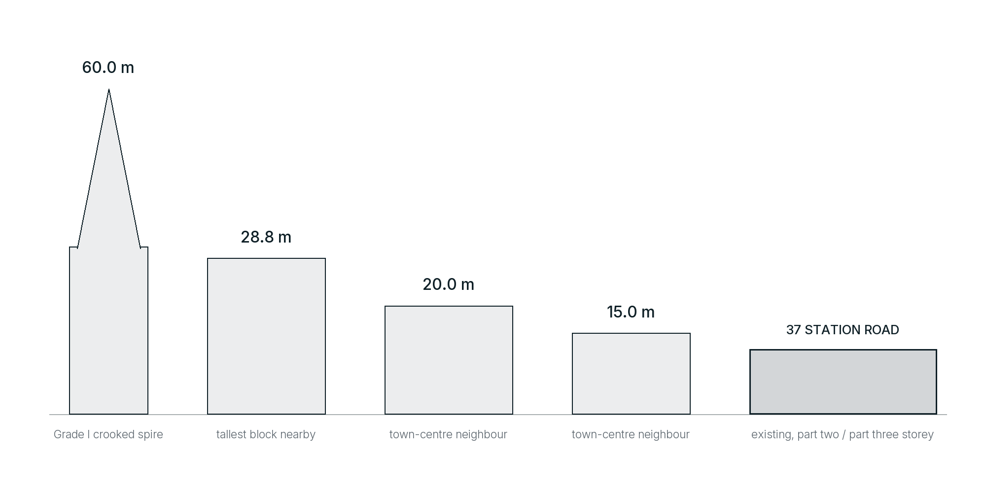
Before any height was proposed on the site, the study modelled the plot in its surroundings and measured what is actually there. The site sits under a 60 m spire, beside blocks of 28.8 m, 20 m and 15 m.

A height comparison drawn from the study's context model: the Grade I crooked spire at 60 metres, a block at 28.8 metres, two town-centre neighbours at 20 and 15 metres, and 37 Station Road itself as an existing part two, part three-storey building

Redrawn from the study's context model, section 2.3. Heights only, to a common scale: this is not a positional plan, and the subject building is shown at its existing storeys rather than a dimensioned height.

What was produced

Four things, in thirteen days.

The site read
Levels, access, flood risk, heritage, mining record, planning history
The massing
The plot modelled in context, neighbouring heights measured
The routes
Two options drawn as floor plans at 1:200, not sketched on the particulars
The schedules
Every apartment listed: type, bedrooms, area in sqm and sq ft, parking

The first study issued eight days after the client's information arrived. The second route followed five days after that.

Why it is the schedule that matters

The part an appraisal eats.

Unit count, bedroom mix, floor area in square metres and square feet, one parking space per home. Set those against a sale rate and a build rate and the answer becomes arithmetic rather than opinion.

And it arrives ahead of the ground investigation, the coal-mining risk assessment and the consultant reports a planning application will need.

Before
A line in the particulars about redevelopment potential
After
Two drawn routes, with real areas to price against
The two routes

Convert for thirteen, or build for sixteen.

Rather than force a single answer, we drew both and scheduled both, so capacity, mix and floor area could be compared against the cost and risk each route carries. Each keeps the locally listed building.

The new-build route

Sixteen homes on the cleared land.

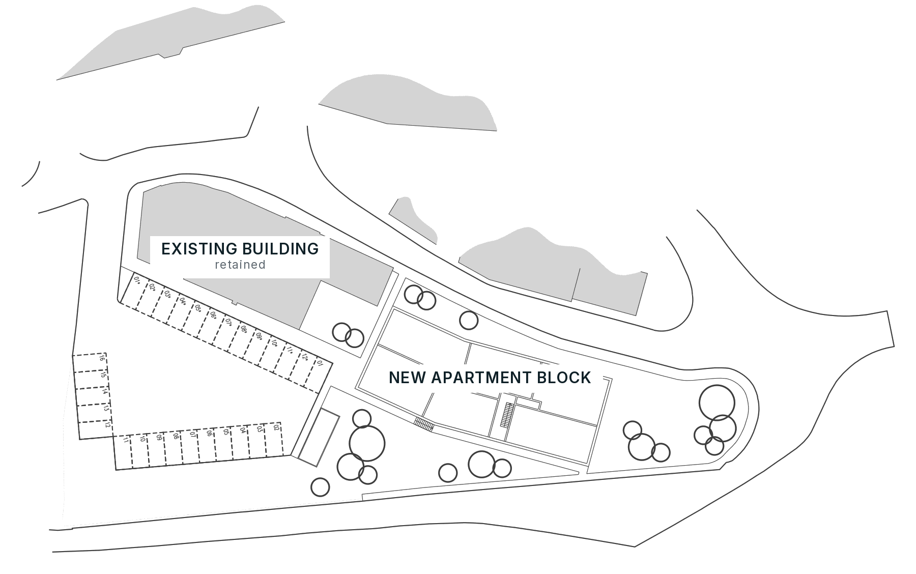
The 7.5 m fall is worth a floor: a lower ground level cut into the slope adds homes without adding visible height from the street. The mass follows the listed building's line and steps back to keep its view from the station approach open, with the top floor pulled to the northern corner.

Feasibility site plan of the new-build route at 37 Station Road, Chesterfield: the existing listed building retained in grey at the Station Road frontage, with a new apartment block on the cleared land behind it and parking bays worked into the sloping plot

The new-build route. The existing listed building is kept, shown grey at the Station Road frontage, with the new block set on the cleared land behind it. Rickett Architects feasibility sketch, redrawn.

The conversion, ground floor

Homes shaped to the walls.

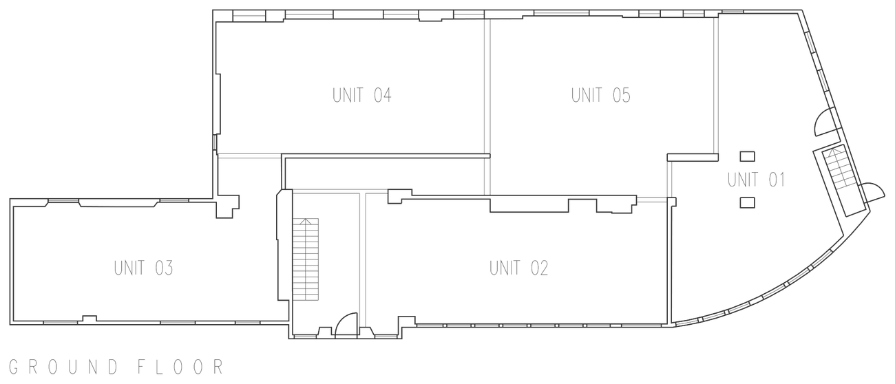
The listed building is an awkward, tapering shape with a curved end, so the units are shaped to the existing walls and served off two retained stair cores, every front door within reach of a protected core. The original entrance, one of the features that earned the listing, stays as the way in.

Feasibility ground floor plan of the conversion route at 37 Station Road, Chesterfield: five apartments, units 01 to 05, fitted within the irregular tapering footprint of the listed building and served off two staircases

Ground floor: units 01 to 05, five two-bedroom homes worked around the existing structure.

The conversion, first floor

Five more, over the same plan.

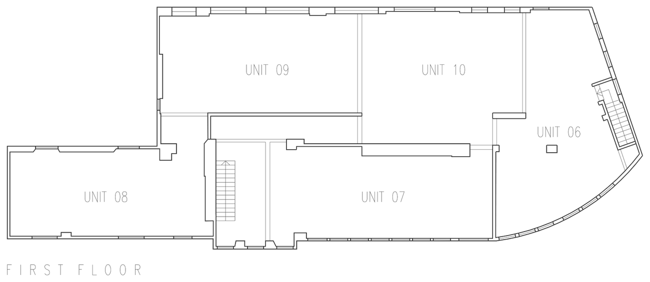
Ten homes across the two floors, five on each, with circulation kept tight to protect the yield. A set-back additional floor would take the conversion to thirteen: recessed from the roofline, it reads clearly as new against old and increases the separation to neighbours.

Feasibility first floor plan of the conversion route at 37 Station Road, Chesterfield: five apartments, units 06 to 10, over the ground floor and served off the same two staircases

First floor: units 06 to 10, over the same footprint. The set-back third-floor option is not shown.

The constraint that decided it

The heritage set the number.

Keeping the building was the commercial answer, not just the polite one.

An earlier independent planning appraisal was blunt: retain and convert the stone range and prospects are good; demolish it and the harm is significant and the case much weaker. Both routes keep it.

Test a site before you commit
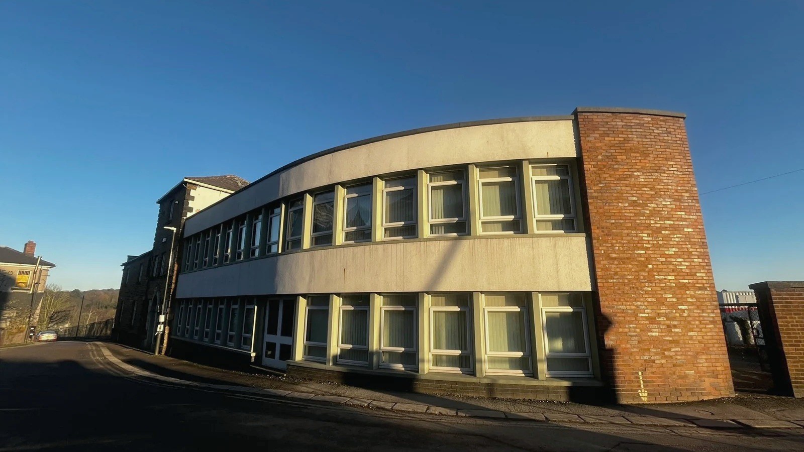
37 Station Road, Chesterfield as it stands: a part two, part three-storey former office with its 19th-century stone range at the left and a later curved rendered frontage with a red-brick stair tower, on a plot running as a surface car park

The building as it stands. The stone range at the left is the locally listed part, ref 155 on Chesterfield Borough Council's Local List since 2019; the curved frontage and brick stair tower are 20th-century additions. The site is outside, but on the boundary of, the Town Centre Conservation Area.

The full story

37 Station Road is the last survivor of the former Derbyshire Times newspaper offices, on the approach from Chesterfield station into the town centre. The printworks and later additions that once wrapped around it were demolished under a 2013 consent that kept the stone building; a later attempt to run the whole plot as a car park was refused, and the land drifted. In 2019 the 19th-century range was added to the council's local list of heritage assets.

A locally listed building is not a statutory listed one, but it is not a free hand either. Council policy sets a presumption in favour of keeping it. Treated as an obstacle it would have capped the scheme; treated as the organising idea it gave both routes a defensible starting point. Around that sat the ordinary difficulty of a tight town-centre plot: about 7.5 m of fall, access from Station Road alone, known coal-mining ground with recorded tunnels, and the protected views of the Grade I crooked spire of St Mary and All Saints to the west.

The study also set out what this town centre has already consented within a short walk. An office building was granted change of use to thirty apartments in 2018. A Grade II listed building was granted conversion to ten. The former county court was granted twelve dwellings in January 2019. On a site the local plan's Spire Neighbourhood policy already supports for housing, that is the comparable evidence an appraisal wants sitting behind its assumptions.

What the study does not do is settle everything. The coal-mining ground will need a risk assessment before habitable development. The spire views and the conservation-area setting still have to be argued. The feasibility is complete; a pre-application discussion with Chesterfield Borough Council is the recommended next step, and no planning application has yet been made.

The outcome

A marketing line, replaced by a schedule.

RIBA Stages 1 to 2: the site read, the massing model, two drawn routes and an accommodation schedule for each, delivered inside two weeks and ahead of any ground investigation or planning application.

What was delivered

Two routes, both scheduled.

Route one
Convert the listed building for 10 homes, or 13 with a set-back floor
Route two
Build new on the cleared land for 16 homes over four levels
With each
Unit mix, floor areas in both measures, and the parking count
Both
Retain the locally listed range

Alternatives, not a combined scheme. The numbers are not additive.

What it settled

The appraisal stops being a guess.

Capacity
What the site carries, at the scale it will actually take
Area
Gross and net internal, in square metres and square feet
Route
Which of the two is the stronger planning case, and why
Timing
Before the spend that a planning application commits you to

That is what a feasibility is for: replacing a hopeful assumption with something an appraisal can stand on.

What is not settled

Said plainly, in the study.

Mining
A coal-mining risk assessment before habitable development
Heritage
Spire views and the conservation-area setting still to be argued
Consent
None. No planning application has been made
Next
A pre-application discussion with Chesterfield Borough Council

Demolishing the locally listed range would carry significant heritage harm and a much weaker case. That is why both routes keep it.

Tell us about your project

Holding a site you have not tested?

A Senior Architect will reply. We will give you an initial appraisal and guide you as to what to do next.

Your enquiry will go directly to a Senior Architect.

Thank you. A Senior Architect will reply personally.
Something went wrong sending this. Please call 01926 967 090 or email studio@rickett.co.uk.