Your land's development potential.

What makes a site developable. And how to find out.

Reviewed August 2026
The short answer

Most land is not developable, and the reasons are usually settled before anyone draws anything. Three questions do most of the work: what the development plan says about the site, whether it sits inside a settlement boundary, and whether it can be reached, drained and serviced.

In practice · Shirley

A working farm, tested for homes

The cheapest way to find out what land can carry is to test it on paper, before anyone applies for anything.

The order of work
01Read the planDesignation, settlement boundary and allocation, before anything else.
02Map the constraintsAccess, drainage, levels and ecology recorded on the ground.
03Test the capacityParcels drawn and redrawn until the land shows what it holds.
04Put the caseEvidence into the plan process, not a planning application.

Land at Woods Farm sits on the southern edge of Shirley, in Solihull, with a canal along the south and the main line to the west. It is a working farm, and the whole holding sits in the West Midlands Green Belt.

The job
Site
A working farm on the southern edge of Shirley, Solihull
Role
Lead architect and masterplanner, RIBA Stages 1 to 2
Scope
Pre-application document, design code and green infrastructure masterplan
Outcome
429 homes tested across nine parcels. No application made

The instruction was to establish what the land could hold and to make the case for it. Nine parcels were drawn and tested at 35 dwellings to the hectare, which came to 429 homes, with a reasoned case for up to 460. A design code and a green infrastructure masterplan went with the layout, so the figure was never a figure on its own.

More

This was a promotion, not an application. No planning application was made and no consent was granted. The site was promoted as proposed allocation BL3 in the Solihull Local Plan Review, and the work ran through 2022 and into late 2023.

The owner still ended up knowing what the land could hold, what the layout would look like and where the argument would be hardest, with nothing applied for and no decision to wait on.

A promotion runs on the plan's timetable rather than the owner's. An authority reviews its local plan on a cycle measured in years, and a site is considered when the review reaches the stage that considers sites. That is why promotion and application are usually treated as separate tracks rather than one after the other.

The other thing a test of this kind produces is a reason to stop. A capacity study that comes back at a third of what the owner assumed is a cheap answer, and it arrives before the money is committed rather than after.
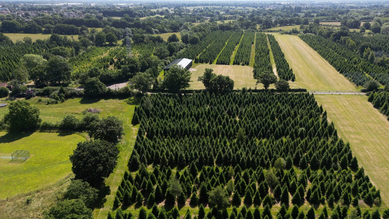
An aerial photograph of Woods Farm, Shirley: dense rows of planted conifers filling most of the frame, a single large farm shed with a pale roof, mown grass strips between the rows, mature oaks along the field boundaries and the roofs of Shirley beyond the treeline.
Woods Farm from the air, with Shirley beyond the treeline.
The proof

Four sites, four different answers.

Outline consent · granted

The Laurels, Little Kimble

A field on the edge of a Buckinghamshire village, taken from raw land to outline consent for up to 14 homes, with the section 106 securing 48 per cent of them as affordable. Committee resolved in 2019 and the decision issued once the agreement was signed. Deanfield Homes bought the consented site and built it out.

Wycombe District Council ref 18/07975/OUT · granted 2020
Capacity test · 595 homes

Park Farm, Thornbury

A consent for up to 595 homes was already in place at Thornbury, won at appeal by others. Cala Homes and Legal & General Homes needed to know whether that capacity really fitted on the ground in their own house types. Plotting it and testing it took a fortnight, and it informed a land decision.

South Gloucestershire · feasibility for Cala and L&G, 2023
Consent · rescued from lapse

Brooklands Farm, Southam

Three homes on a redundant farmyard at Southam, consented in 2021. Three years on, the permission was within weeks of lapsing. Foundations were begun in time and a certificate of lawful development confirmed that start as lawful, which is what keeps a permission alive and a scheme completable.

Stratford-on-Avon DC ref 25/00527/LDE · granted May 2025
Habitat bank · 68 acres

Wood Farm, Everdon

A habitat bank in Northamptonshire. Dan Rickett, a director of the practice, owns it. Land that will not carry houses can still carry biodiversity units, and for a field that was never going to be a housing site that is a use in its own right. Units are sold through a broker.

Everdon, Northamptonshire · 68 acres under management

Every planning application we make in our own name is a matter of public record on a council register, and ours reach more than 100 planning authorities across the UK.

Architects for developers →
The first step

Not sure what your land can take?

Send us your project and where it is. A Senior Architect will give you an initial appraisal and guide you as to what to do next.

Start a conversation
01 · Where you stand

Start with the policies map

In England, every local planning authority has to prepare a policies map and keep it up to date, and publish it on its own website. It is the fastest way to find out whether the question is worth asking at all.

Three things on it carry most of the answer. The settlement boundary, which separates the built-up area from open countryside. Any allocation, which is land the plan has already earmarked for development. And any designation lying over the site: Green Belt, a conservation area, a flood zone, protected employment land, a local wildlife site.

More

Worth knowing about that first one: a settlement boundary is not a national rule. It is a line drawn in a local plan, and sometimes in a neighbourhood plan. It binds because decisions have to be made in accordance with the development plan unless material considerations indicate otherwise, which is a strong starting point rather than an absolute one.

Inside the boundary with nothing over it, the argument is about the scheme. Outside it, the argument is about the principle, and that is a longer and more expensive one. Neither is a refusal. They are simply not the same job, and the difference is worth knowing before a penny is spent.

The plan is half of it. The other half is physical, and it is surveyable rather than arguable: whether the site has a safe access onto the highway, where surface water goes, what the ground is made of, what lives on it, and what runs under or over it. A field with no way of reaching a public road is not a development site whatever the plan says.

Both halves can be established before anything is designed, and both cost a fraction of a planning application. The order matters as much as the content, because the cheapest checks are the ones most likely to stop the work.

02 · The routes

How land reaches development

Four routes, and they differ in who carries the planning risk and who is paid for taking it.

Route 01

Sell it as it stands

An unconditional sale at the value the land has today, with no planning risk attached to it. It is the quickest route and the most certain, it needs no consultants, and the price is agreed and paid without waiting on a planning decision.

The trade-off: unless overage is negotiated into the sale, whatever a future consent adds belongs to the buyer.
Route 02

An option agreement

A developer buys the right to buy the land later, usually at a discount to its market value once consent is granted, though some are written at a fixed price. The developer funds the planning work, and you are tied to that one buyer for as long as the option runs.

The trade-off: the discount is agreed at the outset, long before anyone knows what a consent here is worth.
Route 03

A promotion agreement

A promoter funds the planning work, then the consented land is sold on the open market, with the promoter taking its costs and an agreed share of the price. Nobody is buying the land at the outset. They are buying a share of what it becomes.

The trade-off: the land goes to the highest bidder rather than one you choose, and the share comes off the top.
Route 04

Take it through yourself

You commission the work, carry the cost and keep all of the uplift. It suits a site where the planning question is narrow and the answer is reasonably predictable, and an owner who can absorb a refusal without it mattering very much.

The trade-off: the money all goes out before the answer comes back, and a refusal is entirely yours to carry.
Common questions

Land potential, answered

Can I get planning permission on agricultural land?

Sometimes. Farmland carries no special permission to build, and the best and most versatile land carries weight against development on top of that.

More

Agricultural use is not a designation that opens a door; it is simply what the land does now. The application is decided against the development plan like any other, so the settlement boundary and any allocation still do most of the work. Where land is graded 1, 2 or 3a in the Agricultural Land Classification it counts as best and most versatile, and when an authority is allocating land the framework expects areas of poorer quality to be preferred to areas of higher quality. Existing farm buildings are a different question from the fields around them, because in England permitted development rights can convert some of them to homes on a prior approval rather than a planning application.

Can I get planning permission on Green Belt land?

Occasionally. The Green Belt is restrictive rather than absolute, and the exceptions are narrow and specific.

More

The reliable routes start from something that already stands: replacing a building with one in the same use and not materially larger, or redeveloping land that has been built on before without substantial harm to openness. Limited infilling in villages is an exception in its own right, and grey belt, which arrived in December 2024, opened a further route, although it comes with four conditions that all have to be met. Anything outside the listed exceptions needs very special circumstances, which is the hardest and least predictable route there is. A local plan review is the other way land leaves the Green Belt, and it runs to a timetable measured in years.

What does a feasibility study actually cover?

Three things: what the plan allows, what the site can physically take, and what could be built on it.

More

The first is desk work on the development plan, the policies map, the planning history of the site and its neighbours, and any designation over it. The second is physical and surveyable: access onto the highway, drainage and flood risk, levels, trees, ecology, services and anything buried. The third is drawing, because capacity is not a formula. It falls out of a layout that actually works, and until something is drawn the number of homes a site can hold is a guess. The output is a position, not a scheme.

Does planning permission expire?

Yes. In England a full permission normally has to be begun within three years, and an outline gives three years to apply for the reserved matters.

More

The development itself must then begin within two years of the last reserved matter being approved. Time limits differ in Wales, Scotland and Northern Ireland, and an authority can set a different period. Beginning means a material operation, a defined list that includes something as modest as digging a trench for a foundation, but the start only counts if it is lawful, so any pre-commencement conditions have to be discharged first and that is the part that takes time. A certificate of lawfulness can then confirm that the works carried out were lawful, which is what establishes that the permission was implemented. Once a consent has lapsed there is no renewal route: it is a fresh application against whatever policy applies by then, although the old consent still counts as planning history.

What is a call for sites?

It is how land gets put in front of an authority for consideration in its next local plan.

More

The framework expects authorities to understand how much land is available for housing and employment, and they gather that evidence by asking landowners and agents to submit sites. The submission is short, but a site that arrives with a site plan, an access strategy and a worked constraints appraisal is treated very differently from one that arrives as a red line on a map. Inclusion in the assessment is not an allocation and it is not permission. It is the first of several stages, all of which run on the plan's timetable rather than yours.

How much of my land is actually developable?

Less than the red line. Roads, open space, drainage and buffers come out before a single home is plotted.

More

The gross area is what you own. The net developable area is what is left once the spine road and estate streets, the public open space, the surface water attenuation, the ecological buffers, any biodiversity net gain held on site, any easement under or over the land and any part that cannot be reached are taken out. On a greenfield site of any size the difference is routinely large. That is why a density figure applied to a site area is a poor predictor and a tested layout is a good one, and it is the single commonest reason an owner's expectation and a developer's offer are far apart.

What is a section 106 agreement?

A legal agreement attached to the land that secures what a development has to provide alongside the buildings.

More

Affordable housing, contributions to schools, highway works, open space and its future management are the usual contents. It binds the land rather than the person, so it passes to whoever owns the site next, which is why it belongs in any calculation of what consented land is worth. An obligation can only count as a reason for granting permission where it is necessary to make the development acceptable in planning terms, directly related to it, and fairly and reasonably related in scale and kind. Negotiating one is frequently what sits between a committee resolution and a decision notice.

Written by

Rickett Architects

A RIBA Chartered practice, working since 1970, with more than 2,500 projects behind it. Our senior architects take projects from first survey through planning to completion, for private clients, developers and landowners across the Midlands and well beyond it.

Tell us about your project

Got land and no answer?

A Senior Architect will reply. We will give you an initial appraisal and guide you as to what to do next.

Your enquiry will go directly to a Senior Architect.

Thank you. A Senior Architect will reply personally.
Something went wrong sending this. Please call 01926 967 090 or email studio@rickett.co.uk.